Anin Puthukkudy
I am a dedicated Atmospheric Physicist holding a Ph.D. from the University of Maryland Baltimore County (UMBC), USA. My area of expertise lies in aerosol measurement and instrumentation, and I possess a strong foundation in programming languages such as Matlab and Python. I am particularly enthusiastic about the application of aerosol remote sensing techniques and the development of inverse methods to determine aerosol properties using multi-angle polarimetric observations. Throughout my academic career, I have accumulated extensive experience working with the HARP family of polarimeter data, and I have successfully employed the GRASP algorithm to retrieve aerosol properties. My interest in this field began during my undergraduate studies in Physics when I contributed to a project focused on constructing a cavity-based spectrometer for the purpose of measuring trace gases in the atmosphere.
Upon joining UMBC as a graduate student in 2014, my research interests expanded to encompass both in situ and remote sensing measurements of aerosols. Beyond my passion for atmospheric research, I am an avid backpacker who enjoys exploring national forests, an enthusiastic learner always eager to acquire new technological skills, and an informed individual who remains abreast of current events. As a valued member of our team, I am committed to advancing the understanding of aerosols and their impact on the environment. My goal is to contribute significantly to the development of cutting-edge remote sensing techniques and to the broader scientific community, while inspiring others to explore and appreciate the wonders of atmospheric physics.
Experience
Assistant Research Scientist
Projects
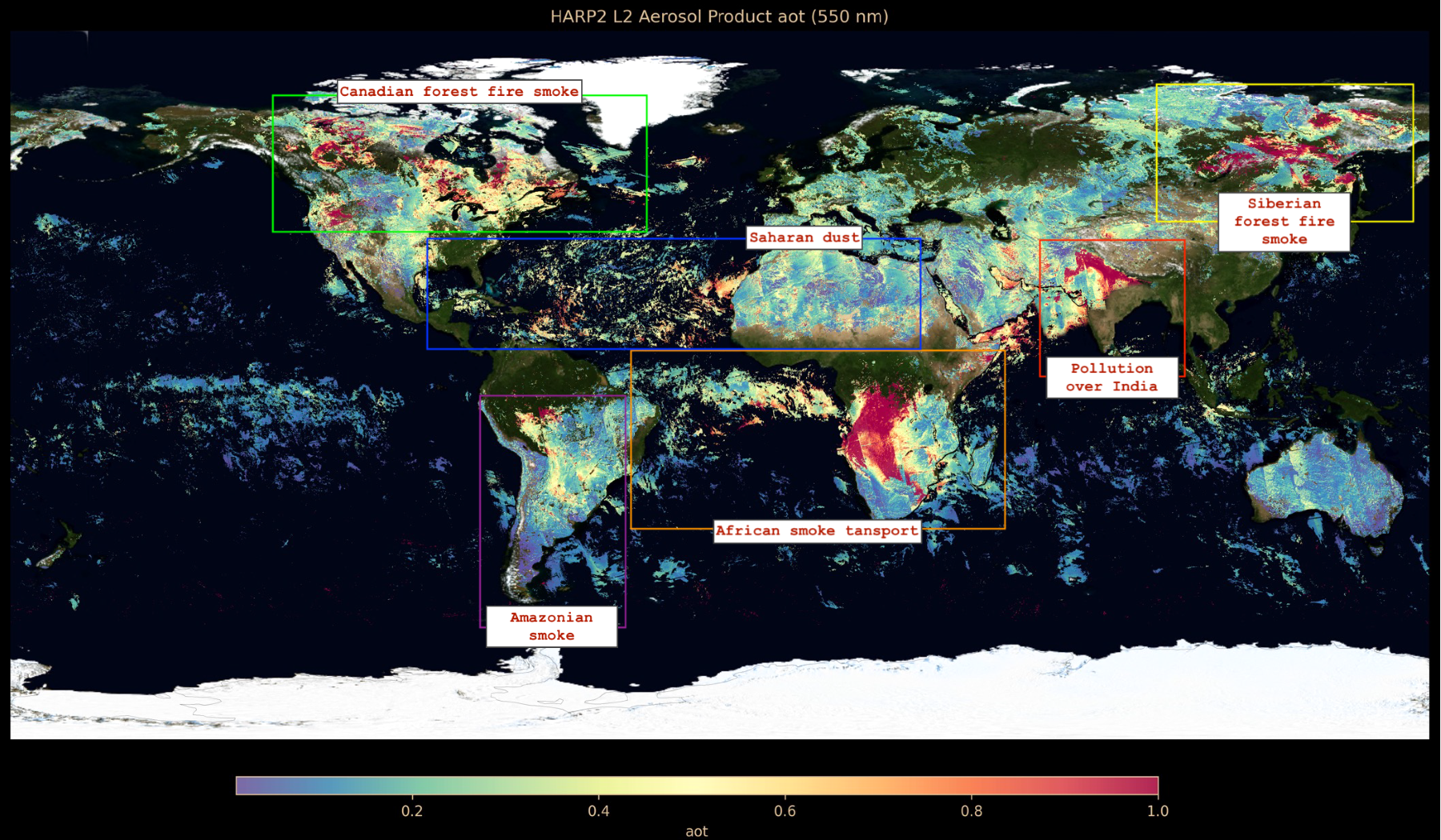
This initiative focuses on crafting an aerosol retrieval algorithm specifically optimized for HARP2 observations, which incorporates multi-pixel data to exploit spatial and temporal correlations. By utilizing the spatially smooth variation in aerosol concentration and optical properties, alongside stable surface characteristics over brief periods, the algorithm employs optimal estimation methods to tackle this complex problem effectively. The efficacy of this approach has been validated using the GRASP algorithm and HARP2 data. Furthermore, this project will facilitate the production of Level 2 aerosol and surface products from HARP2. Currently in the implementation phase, we are collaborating with the NASA PACE SDS team to deploy this algorithm on their distributed system. The system is designed to process each data granule daily, although there is some expected latency due to the intensive computational resources required.
This project entails the continuous monitoring of HARP2's radiometric and spectral calibration. By leveraging the capabilities of other instruments on the PACE platform, such as OCI and SPEXOne, we can assess changes in HARP2's calibration through inter-instrument comparisons. OCI, which shares a wide swath similar to HARP2, allows for cross-referencing observations at -20 and 20-degree viewing angles for top-of-atmosphere (TOA) reflectance. Meanwhile, SPEXOne, with its narrower swath, provides a means to compare polarimetric observations at -50, -20, 0, 20, and 50-degree viewing angles. Additionally, this project includes tracking the radiometric calibration by observing stable Earth targets, such as PICS.
This initiative focuses on creating an instrument simulator that models the path of rays reaching the test instrument at the Top-Of-Atmosphere (TOA). Essentially, the project aims to develop an orbit simulator for any instrument capable of measuring the I, Q, U, and V components of the Stokes vector. This includes simulating the orbit at a specific altitude and inclination, if applicable. With the simulated orbit, based on the instrument's configuration such as swath and pixel footprint, we can calculate the sun-satellite geometry at the pixel level. Leveraging this data, along with climatological information and a 3D/1D radiative transfer code, we can approximate the actual observations made by an instrument with a certain degree of accuracy. This simulation will help us evaluate the performance of the retrieval algorithm in relation to the specific instrument configurations. Consequently, this aids in the selection of spectral bands, viewing angles, resolution, and radiometric and polarimetric accuracies necessary to achieve the desired accuracy of aerosol retrieval products.
Post-Doctoral Research Associate
Projects
This project involves continuous monitoring of the radiometric accuracy of observations made by the HARP CubeSat, in conjunction with other instruments such as MODIS, VIIRS, and ABI. Observations collocated with these reference instruments are utilized to validate the radiometric accuracy of the CubeSat. Additionally, the high-altitude Lake Titicaca is used to verify the polarimetric accuracy, where the low aerosol presence simplifies atmospheric correction. With these corrected observations from HARP, aerosol loading retrievals at collocated AERONET stations are conducted to validate the accuracy of the retrieved aerosol data.
Utilizing actual Particle Size Distribution (PSD) measurements, Top-Of-Atmosphere (TOA) observation was simulated for a conceptual MAP instrument in a 600 km sun-synchronous orbit. By employing various sun-satellite geometries, millions of pixel observations were simulated to encompass a broad range of aerosol and surface characteristics. This approach allowed us to assess the retrieval accuracy, particularly as the complexity of the inverse problem increased from simple to more complex forward modeling. This analysis is crucial for potential users of Level 2 products derived from MAP observations, as the uncertainties identified in this study offer insights into the accuracy of derived and retrieved aerosol properties such as Aerosol Optical Depth (AOD), Single Scattering Albedo (SSA), Angstrom Exponent (AE), Absorption Aerosol Optical Depth (AAOD), refractive index, effective radius, shape, and size distribution.The computational resources for this project were provided by the NASA NCCS DISCOVER HPC system.
HPC is specifically tailored to expedite aerosol retrievals from multi-angular polarimetric observations. This setup was engineered to maintain ultra-low instrument costs while achieving the highest computational efficiency, measured in FLOPS per watt. Additionally, the project included the development of a storage cluster with approximately 0.8PB of capacity, dedicated to managing HARP2 data analysis, encompassing both laboratory calibration measurements and on-orbit observations.
Graduate Research Associate
Projects
In the laboratory, volcanic ash samples are resuspended to assess their microphysical and optical properties. This is achieved using a Polarized Imaging Nephelometer and a Spectral Reflectometer, which respectively analyze the angular light scattering patterns and absorption characteristics of the volcanic ash. Furthermore, samples are collected on a Nuclepore filter after resuspension and subsequently examined using a Scanning Electron Microscope (SEM) to provide detailed imaging of the ash particles to inform on the size and shape of the particles.
This research algorithm is designed to perform aerosol retrievals based on data collected by the airborne version of the HARP instrument (AirHARP) during the NASA ACEPOL and LMOS campaigns. The algorithm processes these observations to extract aerosol properties. The retrieved aerosol products are then compared with aerosol optical depths derived from HSRL2 measurements and collocated AERONET observations to validate their accuracy and reliability.
Analysis is carried out on aerosol measurements obtained with the polarized imaging nephelometer during NASA's DC3 and SEAC4RS airborne campaigns
Undergraduate Research Associate
Projects
As an undergraduate research assistant, I was involved in designing the CAD model of an instrument that measures NO3 and NO2 trace gases in the visible spectral range. This instrument utilizes a high-fidelity cavity and spectrometer to enhance the path length. By employing the spectral cross-section data from the HITRAN database and using the Singular Value Decomposition (SVD) technique, the instrument can measure NO3 concentrations down to 2-3 parts per trillion and NO2 concentrations in parts per billion with high accuracy.
I designed and built an integrating sphere nephelometer from scratch within a month to measure light scattering at 532 nm. This device was developed to measure the scattering efficiency of aerosol particles for gas chamber measurements at University College Cork, Ireland.
Education
University of Maryland Baltimore County
Thesis: Retrieval of aerosol properties using Polarized Imaging Nephelometer (PI-Neph) laboratory measurements and Hyper-Angular Rainbow Polarimeter (HARP) remote sensing observations.
August 2016 - October 2021
University of Maryland Baltimore County
National Institute of Technology Calicut
Thesis: Incoherent Broadband Cavity Enhanced Absorption Spectroscopy for the detection of trace gases using deep red LED.
August 2010 - June 2014
Publications
- Smith, R. E., McBride, B. A., Xu, X., Puthukkudy, A., Sienkiewicz, N., Cieslak, J. D., Remer, L. A., Fernandez-Borda, R., and Martins, J. V.: A new way to see the clouds: the hyper-angular rainbow polarimeter (HARP2) on the NASA PACE satellite mission, Front. Remote Sens., 6, 1710909, 2025
- Sienkiewicz, N., Martins, J. V., McBride, B. A., Xu, X., Puthukkudy, A., Smith, R., and Fernandez-Borda, R.: HARP2 Pre-Launch Calibration Overview: The Effects of a Wide Field of View, AMT, https://doi.org/10.5194/egusphere-2024-2024, 2024
- McBride, B. A., …, Puthukkudy, A., Xu, X., Sienkiewicz, N., Cairns, B., and Barbosa, H. M. J.: Pre-launch calibration and validation of the Airborne Hyper-Angular Rainbow Polarimeter (AirHARP) instrument, Atmos. Meas. Tech.
- Gao, M., …, Puthukkudy, A., and Werdell, P. J.: Simultaneous retrieval of aerosol and ocean properties from PACE HARP2 with uncertainty assessment using cascading neural network radiative transfer models, Atmos. Meas. Tech., 16, 5863–5881
-
Puthukkudy, A., et al., “HARP: A 3U CubeSat for aerosol and cloud observations”, 73rd IAC, Paris, France on 18 to 22 September 2022 (Paper no.: IAC-22/B4/4.7x72125)
2021
- Gao, M., ..., Puthukkudy, A. , ...: Efficient multi-angle polarimetric inversion of aerosols and ocean color powered by a deep neural network forward model, Atmos. Meas. Tech., 14, 4083–4110, 2021
- Dubovik, O., …., Puthukkudy, A., ….: A comprehensive description of multi-term LSM for applying multiple a priori constraints in problems of atmospheric remote sensing: GRASP algorithm, concept, and applications
- Martins, J. V., McBride, B., Puthukkudy, A., Sienkiewics, N., Xu, X., Borda, R. F., Remer, L. A. (2021). First Results from the HARP CubeSat polarimeter. Sensors, Systems, and Next-Generation Satellites XXV (vol. 11858). SPIE.
- Puthukkudy, A., et al: Retrieval of aerosol properties from Airborne Hyper Angular Rainbow Polarimeter (AirHARP) observations during ACEPOL 2017, Atmos. Meas. Tech., 13, 5207–5236, 2020
- Knobelspiesse, K., ..., Puthukkudy, A., ...: The Aerosol Characterization from Polarimeter and Lidar (ACEPOL) airborne field campaign, Earth Syst. Sci. Data, 12, 2183–2208
- Espinosa, W. R., ..., Puthukkudy, A., ..., & Levy, R: Retrievals of aerosol size distribution, spherical fraction and complex refractive index from airborne in situ angular light scattering and absorption measurements. JGR: Atmospheres
- Espinosa, W. R., ..., Puthukkudy, A., ..., & Dolgos, G. (2017): In situ measurements of angular dependent light scattering by aerosols over the contiguous United States. Atmospheric Chemistry and Physics, 1–33.
- Chandran, S., Puthukkudy, A. and Varma, R., 2017. Dual-wavelength dual-cavity spectrometer for NO2 detection in the presence of aerosol interference. Applied Physics B, 123, pp.1-8.
2025
2024
2023
2022
2020
2018
2017
-
Invited Talk at PACE Applications Workshop: "Leveraging Multi-Angle Polarimetry: HARP2 Aerosol Retrieval with GRASP", March 12, 2026
-
Talk at AGU Fall Meeting 2024 on “Retrieving Aerosol and Surface Products Using Multi-Pixel approach from PACE Polarimeter HARP2 Observations with GRASP”, Washington DC, US, December, 2024
-
Talk at APOLO 2024 on “Aerosol and Surface Products from PACE Polarimeter HARP2 Observations using GRASP”, Kyoto, Japan, November, 2024
-
Talk at the CAMP2Ex science team meeting 2024, “Assessment of Aerosol Retrieval Accuracy with Multi-Angle Polarimeters Using Synthetic Data and Particle Size Distribution from the CAMP2Ex Field Campaign”, https://espo.nasa.gov/sites/default/files/pages/CAMP2ExSTM_Agenda_Semifinal3_20240221.pdf (https://docs.google.com/presentation/d/1mHznba5tpuqEmnWA-NaCknaxo-gVib2x/edit#slide=id.p1), February 28, 2024, Pasadena, CA
-
Invited talk at Workshop on “Recent advancements in remote sensing and modeling of aerosols, clouds and surfaces”: "Aerosol and Cloud Observations from Space with HARP CubeSat.", Univ. of Lille, France, May 2023
-
Talk at International Astronautical Congress 2022 : “HARP: A 3U CubeSat for aerosol and cloud observations”, 73rd IAC, Paris, France on 18 to 22 September 2022 (Paper no.: IAC-22/B4/4.7x72125)
-
Talk at AGU2022 Fall meeting: “An assessment of the effectiveness of multi-angle polarimeter aerosol retrievals based on data from the CAMP2Ex field campaign.”. Puthukkudy, A., Espinosa, R., Reid, J.S., Wang, J., Xiao, Q., Ziemba, L.D., Dubovik, O. and Martins, J.V., 2022, December. (Vol. 2022, pp. A55B-06).
-
Puthukkudy, A.et. al: “Aerosol properties from Airborne Hyper Angular Rainbow Polarimeter (AirHARP) observations during ACEPOL 2017”. AeroSat 2020 (Talk)
-
Puthukkudy, A et. al: “Retrieval of aerosol properties from HARP observations”, AGU Fall meeting 2020 (Talk)
-
Puthukkudy, A et. al: “Retrieval of aerosol properties from Airborne Hyper-Angular Rainbow Polarimeter (AirHARP) observations during the 2017 ACEPOL campaign”. GRASP, LOA, University of Lille, France (Talk)
- Puthukkudy, A., Espinosa, R., Lima, A.R., Remer, L., Colarco, P., Whelley, P., Krotkov, N., Young, K., Dubovik, O., Wallace, K. and Martins, J.V., 2017, December. Microphysical Properties of Alaskan Volcanic Ash. In AGU Fall Meeting Abstracts
-
Puthukkudy, A, et al.: “Retrieval of Aerosol properties using GRASP from AirHARP observations”. AGU Fall Meeting Abstracts. 2018
-
Puthukkudy, A., Espinosa, R., Lima, A.R., Remer, L., Colarco, P., Whelley, P., Krotkov, N., Young, K., Dubovik, O., Wallace, K. and Martins, J.V., 2017, December. Microphysical Properties of Alaskan Volcanic Ash. In AGU Fall Meeting Abstracts
2026
2024
2023
2022
2020
2019
2018
2017
Skills
- GRASP - Generalized Retrieval of Aerosol and Surface Properties
- UNL-VRTM - University of Nebraska-Lincoln Vector Radiative Transfer Model
- nasa-pace-data-reader - PyPi package developer of nasa-pace-data-reader - a tool for easy reading of NASA PACE instrument data
Projects
Neural Network Based Radiative Transfer Using 6SV
This project explores emulating the 6SV (Second Simulation of the Satellite Signal in the Solar Spectrum) radiative transfer simulator at the Top-Of-Atmosphere (TOA). The goal is to train a surrogate deep neural network model that can rapidly emulate radiative transfer computations across a wide range of aerosol types and loadings, replacing computationally expensive physics-based simulations with near-instantaneous neural network inference.
The primary focus is on producing the apparent reflectance and Degree of Linear Polarization (DoLP) at the TOA. To achieve this, we created a 16-million datapoint training dataset using Latin Hypercube Sampling (LHS) over the full range of sun-satellite geometry, aerosol properties, and surface properties. The dataset is generated separately for Land and Ocean surfaces, and individual surrogate models are trained for each surface type.
The 6SV-NN training experiments showed that the largest gains in emulator accuracy came from improving the training setup rather than making major changes to network size. Across the saved experiments, the most important factors were increasing dataset size, using physically meaningful input features, and choosing loss functions and target transforms that matched the behavior of the radiative transfer outputs. The final workflow consistently used a moderate multilayer perceptron architecture (15-256-256-128-64-3), which suggests that model capacity was sufficient and that later improvements came mainly from better data representation and optimization strategy.
For land cases, increasing the amount of training data produced the clearest and most consistent improvements. In the multi-wavelength setup, performance improved from an RMSE of about 2.50×10⁻³ with 1M samples to 7.87×10⁻⁴ with 4M samples, and then to a best value of 5.15×10⁻⁴ with the 16M-sample configuration. At the same time, the fraction of predictions within 0.002 absolute error increased from 47.1% at 1M samples to 98.3% at 4M, and to 99.7% in the best 16M run. The best land models also used engineered physical inputs, including angular terms, aerosol descriptors, wavelength, and BRDF parameters (k0, k1, k2), indicating that feature design was an important part of the final performance.
Ocean cases were more difficult and highlighted a different limitation. Larger datasets still helped, with ocean RMSE improving from about 7.05×10⁻³ in an early 200k single-wavelength setup to 2.57×10⁻³ for the 4M multi-wavelength configuration, and further to 2.23×10⁻³ in a 16M multi-wavelength run. However, ocean accuracy did not improve as uniformly as land, because ocean reflectances include many very small values that make relative error unstable. To address this, later ocean experiments added domain-specific features such as pigment concentration, wind speed, and wind azimuth, along with a log-transformed target of the form log(R + 10-4). This change greatly reduced mean relative error from very large values to about 7–9% in the log-target runs, though with some tradeoff in absolute RMSE.
Overall, the experiments showed that the most effective path to improving 6SV-NN performance was not a larger or deeper neural network, but a better formulation of the problem. For land, the combination of larger datasets, physics-informed features, and robust tail-aware training produced excellent emulator accuracy. For ocean, domain-specific features and log-target training were necessary to stabilize relative error. The main lesson is that feature engineering, data scaling, and target/loss design were the dominant drivers of accuracy improvement in the 6SV-NN training workflow.
Architecture & Initial Results
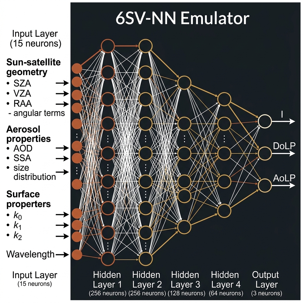
Figure 1: 6SV-NN emulator architecture (15-256-256-128-64-3). Inputs include sun-satellite geometry (angular terms), aerosol properties (AOD, SSA, size distribution), surface BRDF parameters (k0, k1, k2), and wavelength. Outputs are I (apparent reflectance), DoLP (Degree of Linear Polarization), and AoLP (Angle of Linear Polarization).
Total Polarization Ratio
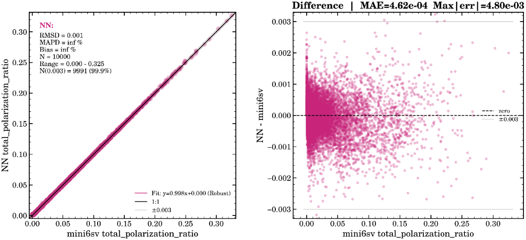
Figure 2a: Truth vs. prediction for total polarization ratio. Left: 1:1 scatter plot (RMSD = 0.001, N = 10,000, 99.9% within ±0.003). Right: Difference plot (MAE = 4.62×10⁻⁴, Max|err| = 4.80×10⁻³).
Figure 2b: Residual distribution (NN − mini6sv) for total polarization ratio. Near-zero centered distribution with MAE = 4.62×10⁻⁴.
Apparent Reflectance
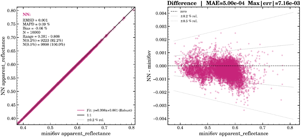
Figure 3a: Truth vs. prediction for apparent reflectance. Left: 1:1 scatter plot (RMSD = 0.001, MAPD = 0.09%, Bias = −0.06%, 100% within ±0.5% rel.). Right: Difference plot (MAE = 5.00×10⁻⁴, Max|err| = 7.16×10⁻³).
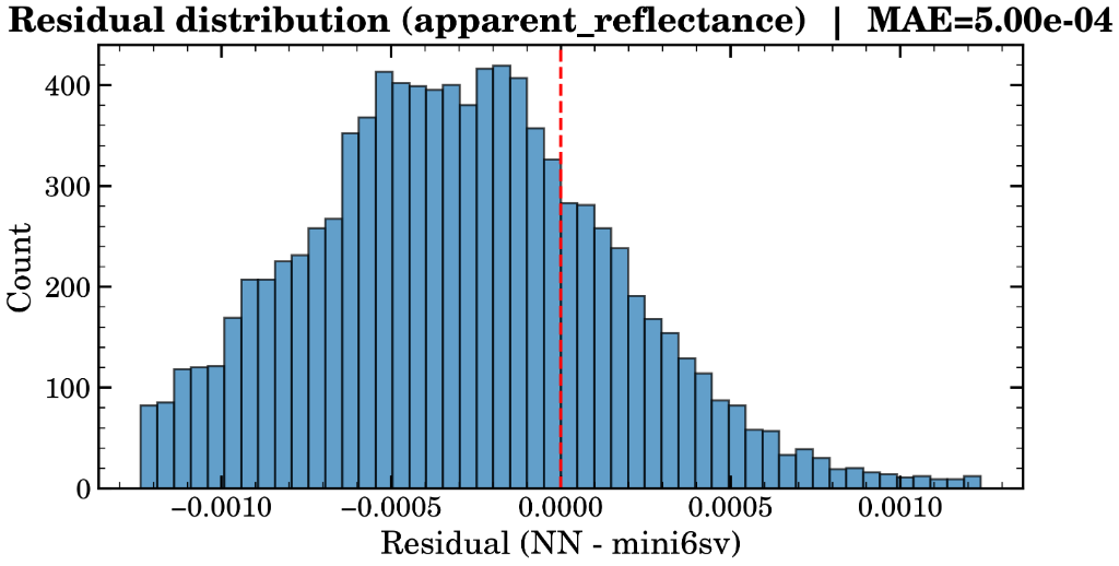
Figure 3b: Residual distribution (NN − mini6sv) for apparent reflectance. Near-zero centered distribution with MAE = 5.00×10⁻⁴.
GRASP Radiative Transfer Using Neural Networks
Building on the surrogate modeling approach, this project employs the GRASP (Generalized Retrieval of Aerosol and Surface Properties) radiative transfer code instead of 6SV to simulate TOA observations. The key distinction is that the GRASP RT forward model simulates the full polarimetric signal — the Stokes parameters I, Q, and U — at the Top-Of-Atmosphere, enabling complete characterization of both intensity and polarization state of the scattered radiation. This surrogate model is particularly suited for multi-angle polarimetric retrievals from instruments such as HARP2 and SPEXOne aboard NASA's PACE satellite, where computational speed of the forward model is a critical bottleneck.
The most important result came from the March 2026 hyperparameter sweep on a 2M-sample land dataset. That search reduced the best validation loss from 0.012198 to 0.010494, about a 14% improvement. Secondary accuracy metrics moved in the same direction: I<1% improved from 12.5% to 13.8%, P<1% improved from 11.0% to 12.4%, and test I(rel≤1%) improved from 12.57% to 13.61%.
The strongest lesson was that a smaller and cleaner model worked better than a larger one. The baseline hidden-layer layout of 512-256-256-128 was outperformed by a compact 256-256-128-64 architecture, which improved validation loss by another 4.7% after batch-size tuning. Larger alternatives such as 1024-512-256-128 and 512-512-512-256-128 were clearly worse, and enabling residual connections also hurt performance significantly. This suggests the model was somewhat over-parameterized for this training regime, and that extra depth or complexity did not translate into better generalization.
On the optimization side, smaller batch size helped. Reducing batch size from 2048 to 1024 gave the single largest early gain, improving validation loss by 6.25%. Larger batch sizes did not help: 4096 was slightly worse and 8192 was much worse. The learning-rate sweep also showed that the original LR=0.001 was already near-optimal. Tested alternatives (0.003, 0.0005, 0.0003) all regressed.
In terms of feature representation, the clearest win was Fourier features. Enabling FOURIER=32 improved validation loss by another 3.7% on top of the better batch size and smaller architecture. A later full-dataset follow-up confirmed this was not just a small-subset effect: FOURIER=32 beat FOURIER=64 throughout training, and by epoch 30 the full-data run reached val=0.00662, with I<1%=20.5% and P<1%=19.0%, substantially better than the earlier 2M-sample experiments. This strongly suggests that moderate Fourier expansion helps the network represent angular structure efficiently, but more Fourier capacity is not necessarily better.
The loss design also mattered. Keeping loss_weights="1 2 1 1" was important — changing to uniform weights (1 1 1 1) caused the largest regression in the sweep, about 48% worse validation loss. That indicates the extra emphasis on polarized radiance was important for overall model quality. Likewise, switching activation from SiLU to GELU hurt performance, so the simpler baseline activation remained the better choice.
Several feature-engineering and target-definition changes were scientifically important. Adding sphere_frac as an input fixed a missing physical dependency and restored sensitivity in Jacobians. Moving to log(Prad) and relative polarization metrics improved target conditioning and made evaluation more physically meaningful.
Overall, the project learned that better GRASP-NN-RT performance came from better conditioning and better inductive bias, not from a larger network. The best tested recipe was: LR=0.001, BATCH_SIZE=1024, hidden layers 256-256-128-64, ACTIVATION=SiLU, FOURIER=32, no residual connections, and loss_weights="1 2 1 1". The broad conclusion is that compact architecture, moderate Fourier features, balanced loss weighting, and physically aligned targets gave the most reliable gains in accuracy.
Architecture & Training Configuration
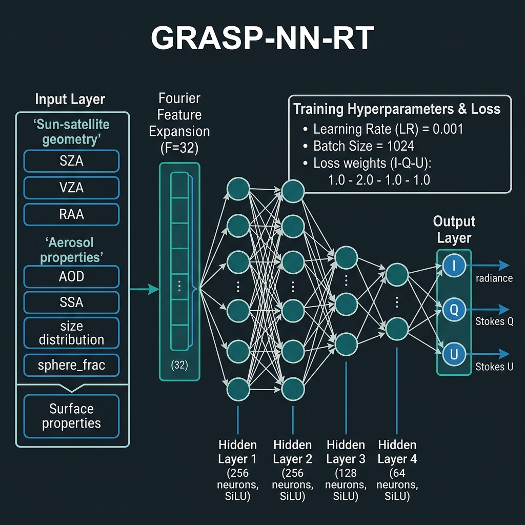
Figure 1: GRASP-NN-RT architecture. Inputs pass through Fourier Feature Expansion (F=32), then through hidden layers (256→256→128→64, SiLU activation). Outputs are Stokes parameters I, Q, and U. Training uses LR=0.001, batch size=1024, and weighted loss (1:2:1:1).
Predicted vs. True (Transformed & Recovered Stokes)
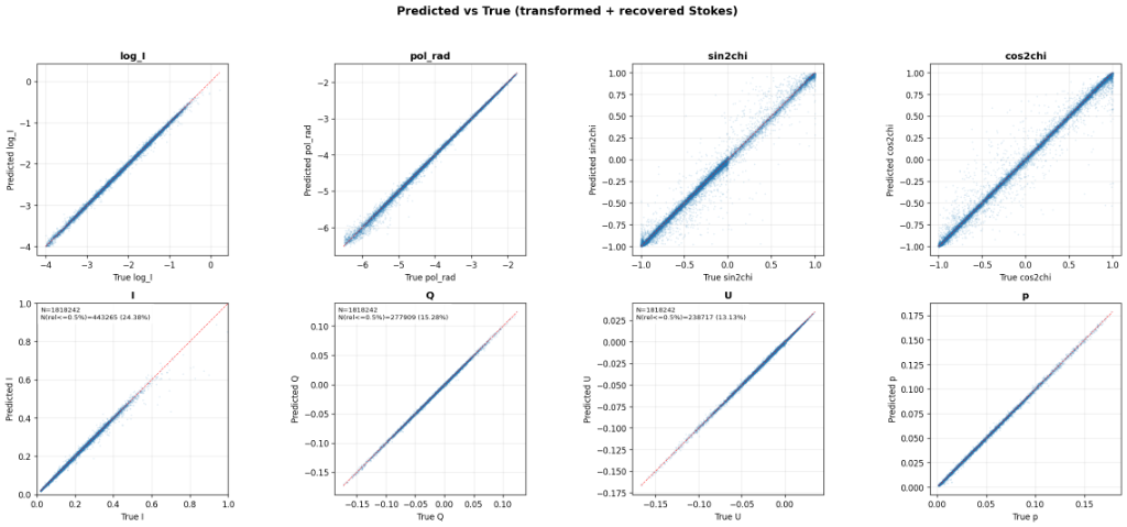
Figure 2: Predicted vs. True for transformed and recovered Stokes parameters. Top row: transformed outputs — log_I, pol_rad, sin(2χ), cos(2χ), where χ is the angle of linear polarization (AoLP = ½ arctan(U/Q)), transformed to sin/cos to eliminate the discontinuity at ±90° and provide a smooth, bounded representation for the network. Bottom row: recovered physical Stokes parameters (I, Q, U) and degree of polarization (P). N = 1,818,242 test samples. I within ±0.5% relative: 24.38%, Q within ±0.5%: 15.28%, U within ±0.5%: 13.13%.
Research Interests
I have a broad range of research interests, including but not limited to the following:
Professional Affiliations and Activities
- Member of the American Geophysical Union (AGU)
- Reviewer for the journals: Remote Sensing of Environment, Geophysical Review Letters, Atmospheric Environment, Atmospheric Measurement Techniques (AMT), Journal of Quantitative Spectroscopy and Radiative Transfer (JQSRT), Optics Express, Review of Scientific Instruments, Remote Sensing, Journal of Applied Remote Sensing (JARS), Journal of Aerosol Science, and Atmosphere, IEEE Trans. on Geoscience and Remote Sensing, Journal of the Atmospheric Sciences, Limnology and Oceanography: Methods, Frontiers in Remote Sensing.
- Editor for the special edition titled ‘Optical and Laser Remote Sensing of the Atmospheric Aerosol and Trace Gases Monitoring’ in the journal Remote Sensing. Initial discussions with the managing editor are underway, with the special issue announcement anticipated by April 2025.
- Guest Topic Editor for the Research Topic "Small Satellites for Earth Observation: Capabilities, Limits, and Scientific Impact" in Frontiers in Remote Sensing (Atmospheric Remote Sensing section), co-edited with Xiaoguang Xu (UMBC) and Anna Gialitaki (National Observatory of Athens). Manuscript submission deadline: September 6, 2026.
- Constructed, managed, and administered a high-performance computing (HPC) and storage cluster: Developed a 20-node HPC and storage cluster from the ground up at the Earth and Space Institute at UMBC for HARP2 data analysis and aerosol retrieval [nyx.esi.umbc.edu]. This involved selecting and ordering components, assembling nodes, and configuring the cluster network. The cluster was designed based on Beowulf architecture.
- Developed a Python package for reading and visualizing PACE instrument data: This package is designed to read Level 1 and Level 2 data from PACE instruments and facilitate their visualization with just a few lines of Python code. Initially, the development centered on the HARP2 instrument. Subsequently, the package was expanded to include support for SPEXOne and OCI instruments. Development is ongoing, with efforts to integrate Level 2 aerosol products from additional instruments into the package.
Other Interests
Apart from being a atmospheric research scientist, I enjoy most of my time being outdoors. I enjoy biking, hiking, backcountry camping.
When forced indoors, I follow a number of sci-fi and fantasy genre movies and television shows, I am an aspiring chef, and I spend a large amount of my free time exploring the latest technology advancements in the scientific computing world.
News
-
Proposal Funded: NASA ROSES 2024 A.36 The Science of PACE - Uncovering coccolithophore and diatom biogeochemical and ecological patterns with combined radiometry and multiangle polarimetry
PI: Dr. Patrick Gray (University of Maine), Collaborator: Dr. Anin Puthukkudy in the proposal for NNH24ZDA001N-PACE:A.36 The Science of PACE

This groundbreaking research will harness NASA's PACE satellite mission to map microscopic marine organisms called coccolithophores and diatoms across the South Atlantic and Southern Ocean. These tiny phytoplankton play enormous roles in Earth's carbon cycle - coccolithophores create calcium carbonate shells that affect ocean chemistry, while diatoms dominate coastal productivity and influence the silica cycle. Both groups act as "ballast" that helps sink organic carbon to the deep ocean, making them crucial for understanding climate change. Using PACE's unique combination of spectral measurements and multiangle polarimetry, scientists will create detailed maps of where these organisms live and how they change with seasons. This research will establish critical baseline data for detecting future changes as oceans become warmer, more acidic, and more stratified due to climate change. The study focuses on three key questions: how these organisms drive carbon export in the Great Calcite Belt, whether they co-exist and trade dominance seasonally in the Southern Ocean, and whether bubbles significantly affect ocean reflectance measurements. More information about NASA PACE is available at https://pace.gsfc.nasa.gov.
-
Proposal Funded: NASA ROSES 2024 A.61 INSPYRE - Deployment of AirHARP2 suite of instruments on the NASA ER2 aircraft for the measurement of pyroCb-injected smoke plumes and their effect on earth's radiative budget
PI: Dr. J. Vanderlei Martins (ESI, UMBC), Co-I: Dr. Anin Puthukkudy in the proposal for NNH24ZDA001N-INSPYRE:A.61 INjected Smoke and PYRocumulonimbus Experiment Science Team
 Forest fires create massive amounts of smoke aerosols that significantly impact Earth's climate and can form powerful pyrocumulonimbus (pyroCb) cloud systems. Understanding how these smoke plumes affect our planet's energy balance has been challenging due to limited satellite observations. This project will deploy the advanced AirHARP2 instrument suite aboard NASA's high-altitude ER2 aircraft to study these phenomena. The AirHARP2 system combines multiple specialized sensors including a hyper-angular polarimeter, imaging spectrometer, SWIR multi-angle imager, and UV imaging spectrometer. By measuring smoke plumes from multiple angles and across different wavelengths, the instruments can determine detailed aerosol properties and how they interact with clouds and surface changes. This research builds on the unprecedented capabilities of NASA's PACE satellite mission, which provides the spectral range and angular measurements needed to accurately assess aerosol impacts on climate. The data collected will help scientists better understand how pyroCb systems inject materials into the stratosphere and modify Earth's radiation budget, addressing critical gaps in our climate models. More information about INSPYRE is available at https://espo.nasa.gov/inspyre.
 -
Proposal Funded: ROSES 2024: A.48 Commercial Satellite Data Earth Science Research and Applications - Advancing Aerosol Property Retrievals with High Resolution Commercial Satellite Data: Leveraging Spatial and Temporal Correlations in Surface and Aerosol State
PI: Dr. Reed Espinosa (NASA GSFC), Co-I: Dr. Anin Puthukkudy in the funded project
 A new research project aims to improve how we measure atmospheric aerosols, tiny particles that affect both climate and human health, by using high-resolution commercial satellite data. Currently, it's difficult to separate the light signals from aerosols in the air from the signals reflected by the Earth's surface. While traditional methods have been limited by the low resolution of government-operated satellites, this new approach uses high-resolution (3-5 meter) and frequently updated commercial data from NASA. The method involves grouping pixels into "superpixels" to account for the consistent nature of aerosols over short distances, then using statistical techniques like Principal Component Analysis (PCA) to remove the distracting surface signals. The remaining data will then be used with an Optimal Estimation (OE) algorithm to accurately determine aerosol properties, such as Aerosol Optical Depth (AOD). If successful, this could provide the fine-scale, daily aerosol data needed for urban air quality monitoring and public health initiatives, even overcoming the higher radiometric uncertainty found in commercial data. More details on the CSDA is available here https://csdap.earthdata.nasa.gov
 -
ESI scientist Dr. Anin Puthukkudy awarded UMBC CIDER grant
"Dr. Anin Puthukkudy, research scientist at ESI, was recently awarded the competitive Center and Institute Departmentally-Engaged Research (CIDER) grant from the UMBC Division of Research and Creative Achievement. The CIDER grant supports collaboration between degree-granting departments and researchers affiliated with a UMBC-based center."
Awards & Certifications
- 2025- CIDER2024 - An AI-driven approach for retrieving aerosol and surface properties from HARP family of multi-angle polarimeter measurements
- 2019 - Travel Fellowship - Received travel fellowship to attend APOLO19 (NASA-GISS, University of IOWA)
- 2017 - 2018 Graduate Student Fellowship - Joint Center for Earth Systems Technology, UMBC
- 2010 - 2013 E-grantz fellow - Won fellowship for the undergraduates by Kerala state government